
Transportation has shaped the evolution and growth of the San Fernando Valley from its very beginnings, bringing ambitious, curious and adventurous pilgrims seeking opportunity. For centuries, hardy travelers walked or rode horses and wagons over the steep, bumpy Cahuenga Pass, through which Native Americans, Spanish missionaries and Overland Stage Coach passengers crossed from the San Fernando Valley into the Los Angeles basin. Over the past 150 years, however, modes of transportation ranging from trains to streetcars to automobiles to the subway have made it easier than ever to undertake that journey. As real estate lured new residents to our area, developers played a major role in devising or promoting new transportation methods to increase land sales. Developments in transportation enabled more and more people to enjoy the Valley lifestyle while commuting to other parts of the L.A. area for work and play, but also led to growing traffic woes and ever-new creative ideas for how to alleviate congestion.


RIDING THE RAILS
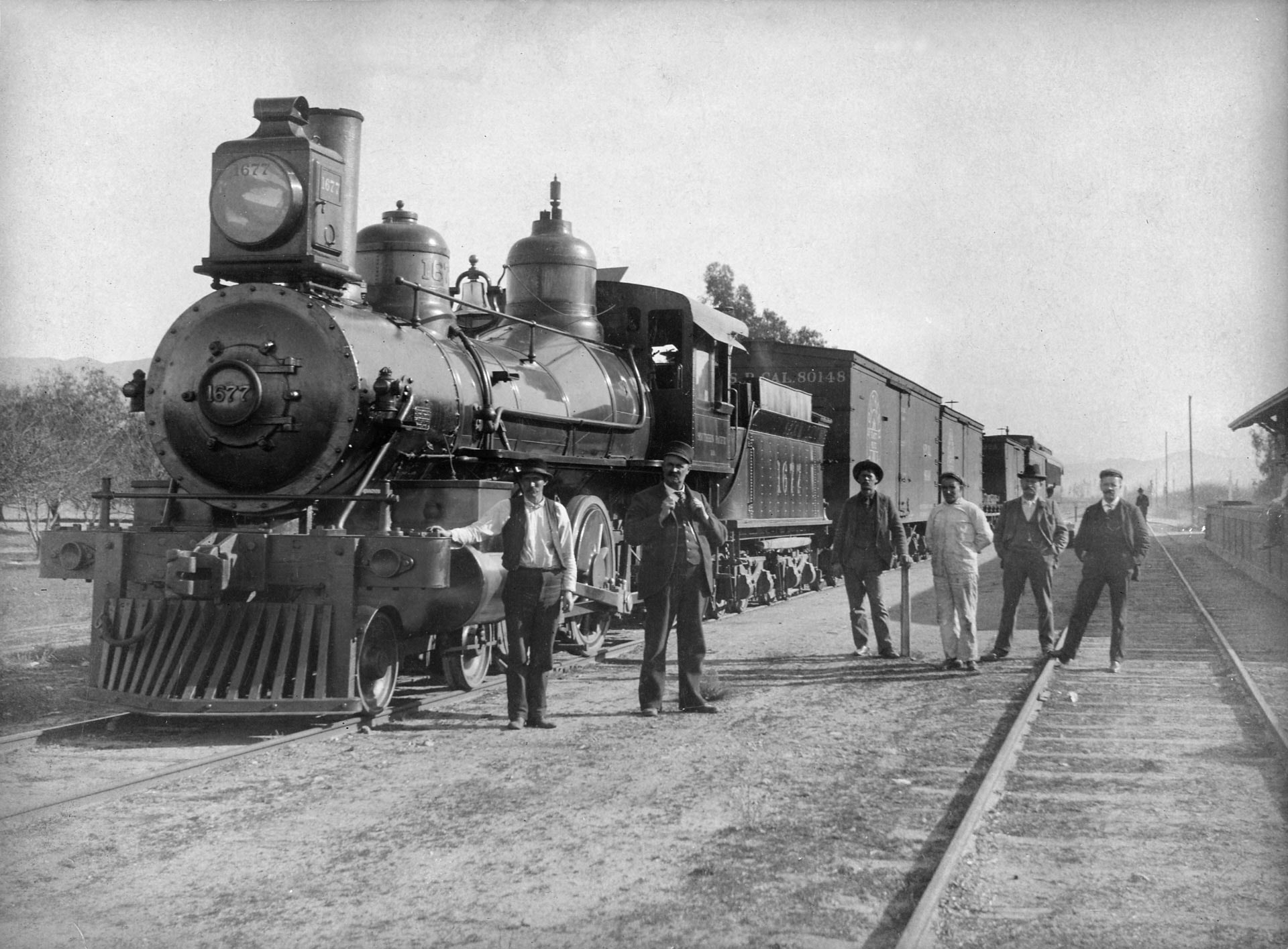
The Southern Pacific Railroad first delivered Midwesterners to Southern California, as they were enticed to the new El Dorado by cheap tickets and land and ballyhoo slogans like “Land of Sunshine.” Trains crisscrossed the San Fernando Valley, transporting eager passengers to Hollywood and Los Angeles and delivering the area’s bountiful crops eastward to feed the country. Industrialists like Isaac Newton Van Nuys and Isaac Lankershim purchased Spanish land grants, subdividing them into large tracts.
Over time, land speculators bought up large swaths to split into small farms and housing developments, contemplating how to quickly bring prospective customers to the largely empty Valley. Astute businessmen like Moses H. Sherman, Eli P. Clark and Henry Huntington established streetcar lines around Los Angeles to sell real estate, converting them to electricity by 1900, the first green form of transportation. Around this time, Huntington began purchasing Sherman and Clark’s interests, along with others, to form what became the Pacific Electric Railway, the largest interurban railway in the United States in the first half of the 20th century, with over 1,000 miles of rail lines.
In 1909, Sherman, Clark, Harrison Gray Otis, Harry Chandler and H.J. Whitley’s Suburban Home Company purchased 48,500 acres in the San Fernando Valley to develop the small town of Van Nuys. The syndicate persuaded Pacific Electric, now owned by Southern Pacific, to construct a new streetcar line from Hollywood through the Cahuenga Pass, up Vineland Avenue to the 1893 Lankershim (now North Hollywood) depot and westward to Van Nuys. Opening on December 16, 1911, the line featured the Rio Vista stop at what is now the northeast corner of Aqua Vista and Vineland Avenue in front of the 1908 Edward A.D. Christopher home, the first residence in Studio City.
Over the next two decades, new lines sprang up around the area thanks to developments like the opening of the Los Angeles Aqueduct in 1913. Routes often ran parallel to streets such as Vineland and Ventura Boulevard, or down the center of others, like Chandler Boulevard. What we know as “little Vineland,” the small street west of Vineland Avenue across from the Garland Hotel, is the remainder of the Vineland streetcar right-of-way.


DRIVING DEVELOPMENT
Employment and prosperity boomed following World War I, allowing the middle class to purchase their first homes and acquire their own automobiles. Ridership peaked on the Pacific Electric in 1922 as car ownership quadrupled between the 1910s and the early 1920s. Busy streetcars and impatient drivers jockeyed for space on increasingly congested streets. Southern Pacific decreased streetcar service and instituted bus routes in order to save money, rather than finding new ways to compete.
Harry Merrick, Hollywood Country Club developer and promoter of Mulholland Highway, conceived the “Five Finger Plan” to alleviate Hollywood traffic problems and facilitate traffic flow to the San Fernando Valley. The plan called for widening certain Hollywood streets; building Cahuenga Boulevard East; paving, curbing and expanding Studio City/Toluca Lake area streets; and adding lanes to the Cahuenga Pass Road, which in 1928 was considered “the most heavily traveled highway in the world.” Expanded highways and streets would also aid construction of Merrick’s proposed Studio City Central Business District, with the Mack Sennett Studio along Ventura Boulevard and a residential district nearby.
The San Fernando Valley population exploded during the 1930s as manufacturing, farming and moviemaking added thousands of new jobs. Rising populations led to growing gridlock on the area’s streets and roads. In the 1920s, city officials began discussing creating a wide system of “motor parkways,” with the Automobile Club of Southern California devising the actual freeway system in 1937 to add free highways throughout the basin to alleviate traffic and speed daily commutes. As early as 1924, Los Angeles voters had approved an express highway between the San Fernando Valley and downtown Los Angeles.
Recognizing the importance of Hollywood and the San Fernando Valley, the Cahuenga Pass Parkway was the second highway to begin construction. Breaking ground on June 15, 1940, with North Hollywood honorary mayor and cowboy superstar Gene Autry cutting a filmstrip in the middle of the Cahuenga Pass near the Pilgrimage Bridge, the first segment of the newly named Hollywood Freeway would extend from Highland Avenue to the bridge and on to Barham Boulevard before concluding near Studio City. $20 million would be required to finish the Hollywood-to-Studio-City stretch of the freeway with four lanes in each direction by 1948. Pacific Electric streetcars ran down the center of the freeway.
Final construction of the Hollywood Freeway to downtown would conclude in 1954. Drivers flocked to the new thoroughfare, overflowing its capacity by almost double within a year of completion, which led Bob Hope to dub it “the biggest parking lot in the world.” Over the next few decades, new freeways would be constructed throughout the county to connect far-flung suburbs with each other. The Ventura Freeway (U.S. 101), stretching from the Santa Barbara–Ventura County line to the Hollywood Freeway, was built between 1955 and the 1960s. California 134, stretching from the 101 interchange to Pasadena, began construction in 1960s and finished in 1971.


SUBWAYS, BIKEWAYS AND BEYOND
Many advocated for the construction of subways in order to facilitate fast travel between distant locations in the early 1900s, including Edward Harriman, the owner of Southern Pacific and Pacific Electric. San Fernando Valley residents also clamored for a subway to downtown in the 1920s in order to speed travel times. In the 1920s, a subway station was constructed in the Subway Terminal Building to remove streetcars from downtown streets and alleviate congestion. A short northern tunnel opening a few blocks away, known as the “Hollywood Subway,” directed traffic toward Hollywood and the San Fernando Valley.
The Los Angeles Metropolitan Transit Authority was formed in 1951 to study rapid and regional transit systems. By 1957, the city authorized it to operate transit lines, leading to the purchase of Metropolitan Coach Line’s bus and streetcar lines, formerly those of the Pacific Electric Railway, and the routes of the Los Angeles Transit Lines, successor to Los Angeles Railway. MTA abandoned all streetcar lines by the 1960s, converting to bus service. In 1964, MTA merged with 11 failing bus companies to form the California Rapid Transit District.
In 1980, voters approved Proposition A, dedicating a half-cent sales tax to organize a regional rail system. Employing some of the old Pacific Electric Railway right-of-ways for routes above ground, construction began on seven transit corridors and subways, including the one for the San Fernando Valley. After tunneling under city streets between downtown and Hollywood in the 1990s, the Valley line tunneled through the Cahuenga Pass before stopping at a station adjacent to the Campo de Cahuenga and one in North Hollywood in 2000.

As transportation costs continued to climb over the decades, many began pushing the use of bicycles as a cheaper and cleaner form of travel. The first protected bicycle lanes actually arose around Los Angeles in the late 1890s as bicycling became all the rage, led by Pasadena businessman Horace M. Dobbins’ elevated wooden California Cycleway with its own dedicated right-of-way from Pasadena toward downtown Angeles in 1899. Though less than two miles of the proposed Cycleway was completed, it allowed fast movement and protection of riders before the advent of automobiles.
Bicycle use exploded in popularity in the early 1970s during the energy crisis and as some master-planned communities included them as a principal form of transportation. Los Angeles City Councilman Marvin Braude suggested constructing bike lanes along scenic highways and beachfront in the early 1970s, and some local communities began adding their own lanes in 1975.
In 2011, the City of Angeles approved a bicycle master plan with more than 1,600 miles of proposed bikeways, slowly adding dedicated lanes, expanding public transit and lowering vehicle speed over time. The MTA later introduced the Metro Bike Share System to allow access to bicycles throughout the city, including North Hollywood. More bicyclists and users of public transportation mean less pollution and fewer cars on the street.
Though residents now have many options for commuting at their disposal, heavy congestion still clogs streets, lengthening drive times. As different solutions continue to be proposed and tried, will public and rapid forms of transportation someday once again become the primary means of travel for Valley residents, as they were more than 100 years ago?

